
⚡
Presentation
Geographer graduated from the Universidad de Los Andes with more than 6 years of experience applying the territory as a decision-making tool. Specialized in spatial analysis, geomarketing, digital cartography and georeferenced data management.
Founder of the ReHabitar method, which integrates sustainability, slow living and eco-luxury to transform spaces from a geographical perspective. I have digitally positioned more than 50 commercial companies on Google Maps and digital platforms, managed property cartography for 1,000+ hectares and developed sustainable content strategies for wellness brands.
📍 Certified in: GIS applied to natural resources | Google Earth Engine | AI applied to territorial analysis (2024)
📍 Languages: Native Spanish | Intermediate English (in training)
Services I offer:
→ Google Business Profile Optimization and Local Presence
→ Geomarketing and Location Analytics for Business
→ Thematic Mapping and Digital Mapping (QGIS, ArcGIS Online)
→ Content Strategy for Wellness/Sustainability Brands
→ Territorial consultancy for slow living and eco-luxury projects
→ Specialized virtual assistance for entrepreneurs in the lifestyle sector
Modality: Remote | Payment: PayPal, Binance, Payoneer, Bank Transfer
Founder of the ReHabitar method, which integrates sustainability, slow living and eco-luxury to transform spaces from a geographical perspective. I have digitally positioned more than 50 commercial companies on Google Maps and digital platforms, managed property cartography for 1,000+ hectares and developed sustainable content strategies for wellness brands.
📍 Certified in: GIS applied to natural resources | Google Earth Engine | AI applied to territorial analysis (2024)
📍 Languages: Native Spanish | Intermediate English (in training)
Services I offer:
→ Google Business Profile Optimization and Local Presence
→ Geomarketing and Location Analytics for Business
→ Thematic Mapping and Digital Mapping (QGIS, ArcGIS Online)
→ Content Strategy for Wellness/Sustainability Brands
→ Territorial consultancy for slow living and eco-luxury projects
→ Specialized virtual assistance for entrepreneurs in the lifestyle sector
Modality: Remote | Payment: PayPal, Binance, Payoneer, Bank Transfer
🛠️
Offered services
📋
Background
CEO
Development of a method that integrates sustainability, slow living and Ecoluxury.
Content strategy, brand building and sustainable digital communication.
Content strategy, brand building and sustainable digital communication.
Goemarketing Specialist | GIS
Mapped and positioned more than 50 commercial companies on Google Maps and digital platforms.
Perform fieldwork and remote management of georeferenced profiles.
Manage visual content: photos, captions, and visibility metrics analysis. Incorporate AI tools into analytics and content creation.
Perform fieldwork and remote management of georeferenced profiles.
Manage visual content: photos, captions, and visibility metrics analysis. Incorporate AI tools into analytics and content creation.
Agricultural Data and Mapping Analyst
Manage property cartography in Qgis for a production unit of more than 1000 hectares. Incorporate a new 160-hectare property into the existing cartographic system.
Develop pasture maps for pasture monitoring and stockload planning. Manage milk production database with continuous registration per paddock.
Develop pasture maps for pasture monitoring and stockload planning. Manage milk production database with continuous registration per paddock.
Quality Control Analysts
I controlled the quality processing of 7 - 15 tons per day between potatoes, strawberries and peaches. Supplier company to McDonald's Venezuela and dairy companies in the Andean region.
Inspect weight, temperature, size, packaging, and hygiene parameters.
Inspect weight, temperature, size, packaging, and hygiene parameters.
Licenciado
Graduated with the title of geographer
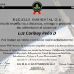
Webinar: Geographic Information System Applied to Natural Resources
Download satellite data with Google Earth Engine and Artificial Intelligence.
Spectral processing and visual interpretation of satellite images.
Introduction to Python and R as a GIS tool
Spectral processing and visual interpretation of satellite images.
Introduction to Python and R as a GIS tool
🇬🇧English 🇪🇸Spanish
🕐
Working hours
Monday
From07h00To18h00
☕From12h00To12h45
Tuesday
From07h00To18h00
Wednesday
From07h00To18h00
Thursday
From07h00To18h00
Friday
From07h00To18h00
Saturday
From07h00To18h00
Sunday ▪ Today
Closed
⭐
Reviews
Please sign in as a customer to give your feedback
💬
No reviews yet.
Be the first to share your experience with this professional.